Nationwide conflict damage mapping with interferometric synthetic aperture radar: A study of the 2022 Russia-Ukraine conflict

Abstract
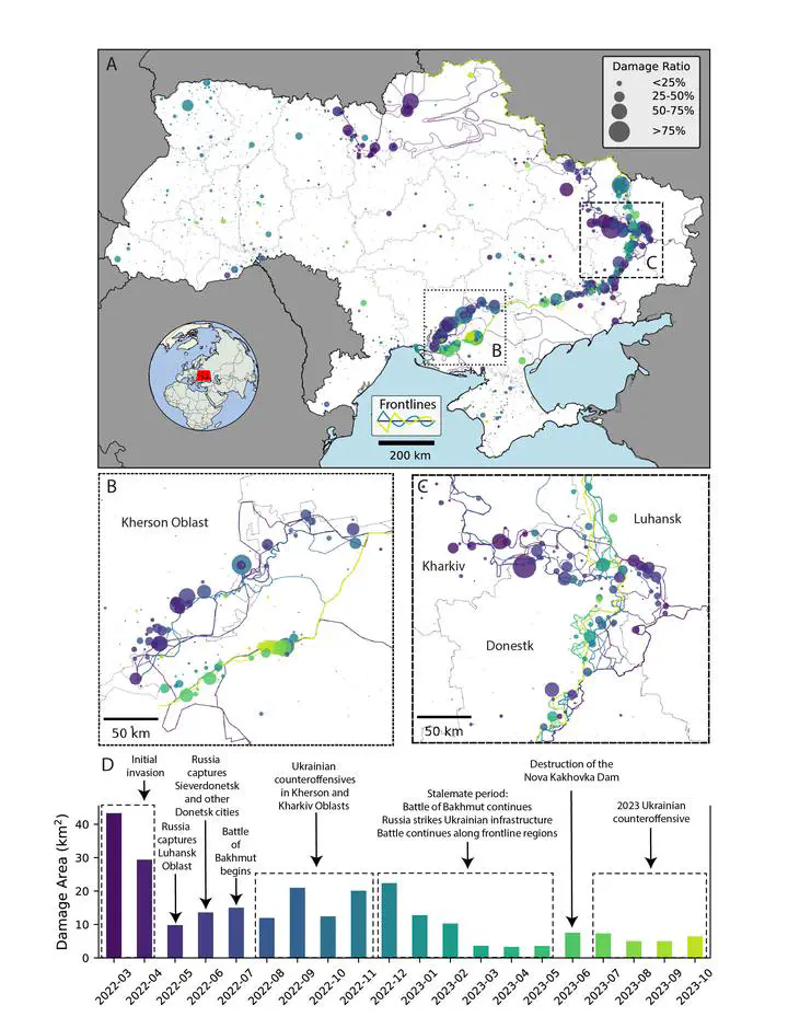
The full-scale Russian invasion of Ukraine that began in February 2022 has killed thousands of civilians, displaced 3.7 million people, and wrought economic damage on the order of hundreds of billions of US dollars. However, the scale, timing, and geographic distribution of damage to Ukraine’s built environment has never been comprehensively assessed. In this study, we use 17,532 Sentinel-1 interferometric synthetic aperture radar (InSAR) coherence images within a coherent change detection (CCD) framework to identify likely damage across human settlements in Ukraine from March 2022 through October 2023. Overall, we map 264 km2 of likely damage across 5.35% (n=2,288) of administrative settlement polygons. The geographic breadth and protraction of this conflict are well captured through remote monitoring. Two thirds (67.0%) of detected damage is within 10 km of the conflict’s front line demarcating territorial control and active fighting between Ukrainian and Russian forces. Damage is detected during every month of the study with one quarter (27.55%) of damage detected during the first two months of the Russian invasion and another one quarter (24.81%) of damage detected during the 2022 counteroffensives in Kharkiv and Kherson. To calibrate our detection approach and assess agreement with known locations of damage, we use data on 17,043 damage locations in 25 Ukrainian settlements mapped by the United Nations Satellite Agency (UNOSAT) and based on visual interpretation of sub-meter optical satellite imagery. Overall, we detect 59.13% of UNOSAT-mapped damage locations in areas under monitoring with false positive rates ranging from 0.81%–1.14% for testing and training partitions respectively, overcoming a major limitation of using Sentinel-1 CCD for nationwide war damage mapping across seasonal cycles. Our approach is scalable, rapid, low-cost, and can be used to prioritize specific regions for in-depth remote or field-based damage assessments. Given the proliferation of urban armed conflicts around the world, the results of this study show a promising path forward not only for nationwide, sustained damage mapping but also for informing post-conflict recovery and rebuilding with a transparent and replicable approach.